Just for fun, I laid the UK over the eastern US with London roughly on top of Atlanta. Edinburgh falls very near Indianapolis. Now from Google maps, the straight line distance from Atlanta to Indianapolis is about 429 miles, while London to Edinburgh is 331. This leads me to believe that this tool is not accurately doing what it purports to be.
When I put London on top of Atlanta (which admittedly is hard to do exactly because the cities in the country getting moved around aren't indicated), Edinburgh lands in southern Indiana, somewhere between Louisville, KY and Evansville, IN.
I could be wrong, but I don't think that's how it works. You're comparing the true size of UK with the flatmap projection of US. To do what you want, you need to compare the true maps of both countries - with the cities.
No, because this map scales the country according to its latitude. So when you drag down England to be next to Atlanta, you're looking at the size of England with respect to Atlanta. The "true size" is just "true" in comparison to whatever it's on top of. So it should be accurate.
It is surprising that a lot of educated folks don't know about this. I always run into folks who think Greenland is the biggest island.
Edit: on Australia being continent - now I come across as a fool. But I hope people understood what I meant. Also, I have had to argue against folks who said Greenland should also be a continent since it is bigger than Australia.
Don't worry manojlds, I'm sure the Pluto people will back you up and demote Australia.
I often wonder if it will matter in a couple of years. If we actually get to the point where walls are displays, then I would expect most schools will have a globe projected on the wall instead of a map. How long until we start with 3D animations instead of 2D drawings?
some definitions are arbitrary, for some people America is one continent, for some there are two, it's human-based, whatever is established in a culture, not math.
Well, since you bring it up, Australia isn't connected to another continent by land like North America is (as are Europe, Africa, and Asia). You'd have to say "the Americas" are an island, or "Afro-Eurasia"
I know, and I never said it was--hence my confusion at being called silly for my post (which was purely objecting to calling North America an island, since it IS connected by land).
If we want to be pedantic about whether or not the Panama Canal turns North America into an island or not, we can change the argument, and ask whether or not the Americas are an island.
There isn't really a single universally accepted list of continents. Some count Australia as continent, some count it as part of Oceania. And some define the continent Australia as the country Australia plus all those islands that would otherwise be Oceania.
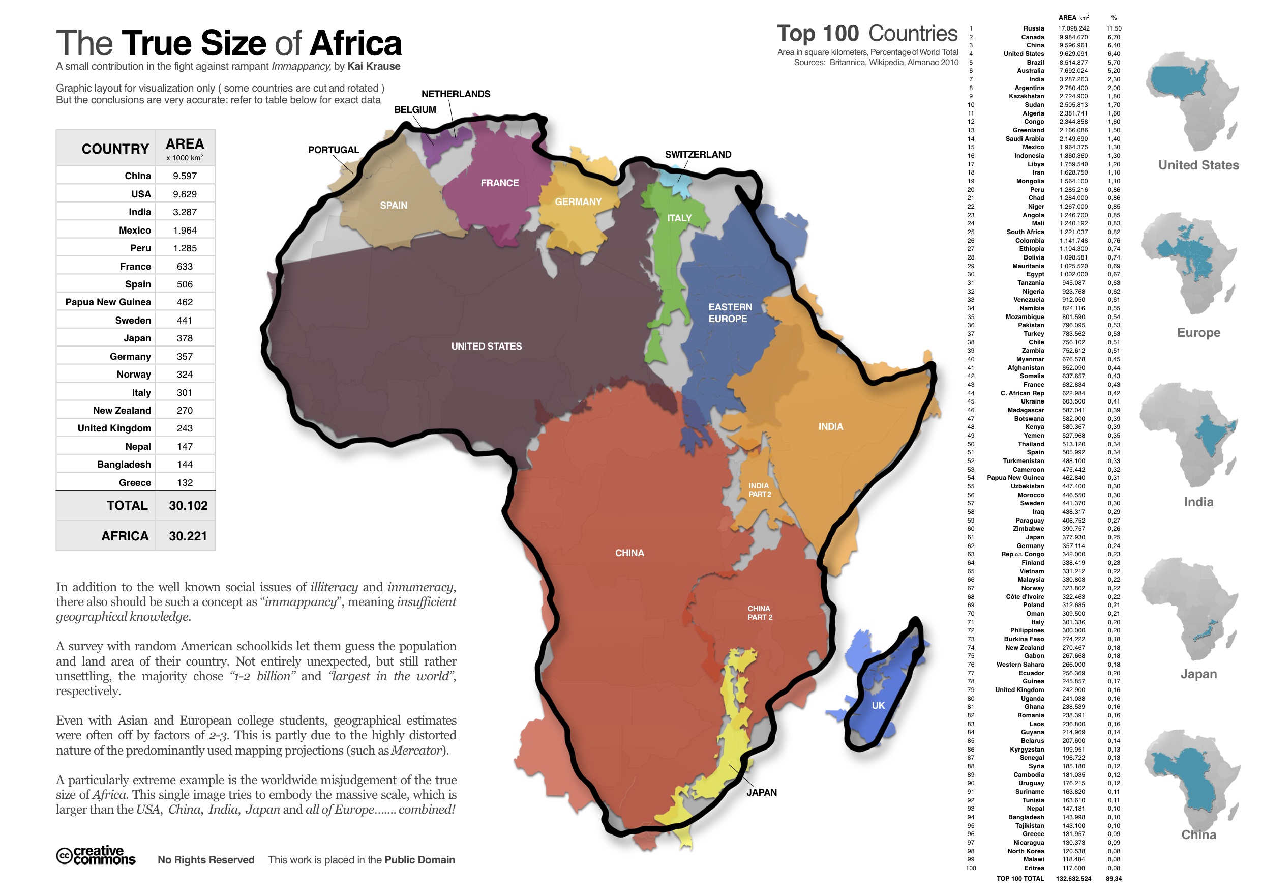
Presumedly that is how they came up with this graphic, which shows Africa encompassing nearly all of the US, Spain, Belgium, Netherlands, France, Germany, Italy, Switzerland, Eastern Europe, India, China, Japan, and the UK in its borders:
This makes me wonder if there's some sort of official world database for how national borders are drawn...
-- how often they're redrawn
-- how often they're updated
-- if there are different/conflicting databases of border data
Surely drawing each line wasn't as straight forward as it appears on maps - in history and in practice.
Small nitpick: The country area is inverted if you move it near the poles. (Maybe because the orientation clockwise/counterclockwise changes implicitly.)
Some countries seems to be impossible to move for me. Morocco and Ghana for example. Also, The Ivory Coast is only searchable by its French name, Côte d'Ivoire, while having its English name on the map.
Edit: Oh, the move issue is not by country. When I reloaded I could move a country I previously couldn't.
Are the shape changes accurate, as you drag north/south? I would expect horizontal borders (like the north border of the USA, which is along the 49th parallel) to stay horizontal as you drag. But in the tool the border becomes more concave as you drag it further south. Why is this?
I'd like to be able to select countries by clicking, rather than text input.
After a couple minutes playing, the site filled firefox history with tens of entries, and I could not return to HN even after hitting back several dosen times.
I notice Puerto Rico and possibly some other territories are missing in the United States selection. Is that deliberate since PR is quite different from the US?
From what I can tell, some of the pre-placed countries are rotated probably on purpose, you can unrotate them with the compass. I haven't seen the issue with any country added via the search.